

Wildlife Conservation Gets a Technology Boost
by Bindu Gopal
Protecting wildlife is getting a tech boost that overcomes the challenges of terrain, weather, and limited manpower to study, protect, monitor, and plan strategic conservation goals. India’s wilderness is learning to speak a new language, one written in signals, sensors, and silent data.
Making a Difference
Technology is being extensively used in wildlife conservation in India through diverse and innovative tools such as Unmanned Aerial Vehicles (UAVs), GPS tracking collars, camera traps, AI, and geospatial technologies. These technologies enable efficient monitoring, protection, and management of wildlife and their habitats. India’s wildlife conservation efforts leverage a synergistic integration of technologies to enhance wildlife monitoring, combat poaching, and manage habitats more efficiently, thus contributing to the preservation of its rich biodiversity. The Wildlife Trust of India (WTI) has also developed HAWK (Hostile Activity Watch Kernel), a cloud-based, centralized forest and wildlife crime management system, which is currently adopted by four government Forest Departments.
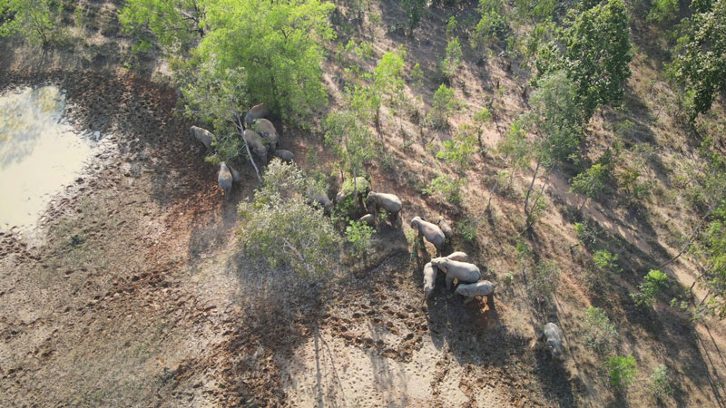
GPS tracking collars, drones, and GIS/satellite imagery are being used in the forests and wildlife corridors for monitoring animal movements and habitats. GPS tracking collars are regularly used to monitor the movements of all sorts of wildlife. Either for ecology studies or tracking potentially problematic individuals—tigers or elephants in particular—integrating GPS collar signals with GIS-integrated layer maps to understand migration patterns, home ranges, land use, and vulnerable areas that animals may be moving to improve management of wildlife and protected areas. Thermal camera-equipped drones are used to monitor fires and human and wildlife movement in dense cover, track specific species like rhinos or elephants in flood-affected or hard-to-access country, do corridor mapping, do anti-poaching, and check on fires. They are used as they can cover much larger areas quickly to get real-time information on water holes, habitats, fences, and wildlife, especially in open country like grasslands or trans-Himalayan desert landscapes. Many projects combine multiple technologies—drones with thermal sensors & cameras, GPS, camera traps, and alert systems—connecting these with ground teams, especially regarding poaching and wildfires.

Shri. Ganga Singh IFS, CCF (HoFF), Shri. K R Jyothi | Photo courtesy of the Wildlife Trust of India (WTI)
Conservation Cues
Across Central India, GPS collars on tigers and leopards have revealed how they move between forest patches and community lands, crossing rivers, roads, and railway lines under the cover of night. This has helped conservation planners identify corridors that might otherwise have been lost to human expansion. Thermal drones are now used to monitor and reduce conflict by spotting elephants or tigers near village fringes during night patrols, allowing staff to respond before any damage or panic occurs. Similar drone-based monitoring has also been extended to wolves. Technology listens as much as it sees: Acoustic monitoring devices, small mouthpiece-style detectors, record ultrasonic calls of bats, allowing scientists to identify species purely through sound frequencies. “It’s a remarkable way of mapping hidden diversity, especially in rainforest canopies.” says Amith Bangre, an award-winning naturalist, conservationist, and wildlife educator. Together, these innovations have made conservation less about guesswork and more about understanding, giving us new ways to protect old wisdom.
In 2022, to better understand the ecology and behavior of sloth bears (Melursus ursinus), Wildlife SOS, in collaboration with the Karnataka Forest Department, collared ten sloth bears in three districts. The long-term study monitors how these bears navigate fragmented forests and agricultural landscapes, collecting detailed data on movement, habitat use, and interactions with human-populated areas. Kartick Satyanarayan, co-founder and CEO of Wildlife SOS, says, “In 2023, in Sonmarg, Jammu & Kashmir, six Himalayan brown bears (Ursus arctos isabellinus) were fitted with GPS collars to study their movement across alpine terrain and proximity to human settlements. Preliminary findings highlighted brown bears frequently visiting garbage dumps in human-adjacent areas, guiding conservation planning and conflict mitigation. In 2018, in Mahasamund, Chhattisgarh, GPS-enabled collars tracked Van Devi, the matriarch of a 21-member elephant herd, forming the backbone of the Early Warning Alert System (EWAS). The system helped prevent human–elephant conflict by sending alerts to nearby villages as the herd moves through croplands and human habitations.” Across all initiatives, GPS technology provides fine-scale spatial and temporal data essential for identifying conflict hotspots, critical corridors, feeding grounds, and seasonal migration routes, enabling targeted conservation measures and safe coexistence between wildlife and local communities.
GIS and Satellite Imagery
These layers reveal how the land changes over time: grasslands, forest cover, and river courses. Satellite mapping has guided the restoration of grasslands for swamp deer recovery. In the Anamalai–Parambikulam region, GIS mapping identified elephant corridors through plantations, helping direct mitigation measures. Dr. Sandeep Kumar Soni, Assistant Manager and OiC (GIS Cell), Wildlife Trust of India, says, “GIS mapping technology plays a crucial role in wildlife conservation by providing powerful tools for habitat mapping, protecting habitat suitability, distribution modelling, species tracking and movement behavior, risk analysis, and conservation planning. Through spatial data integration and analysis, GIS empowers conservationists to make informed, precise decisions to protect wildlife and habitats and plan interventions on a scientific basis.”
GIS is the memory of the landscape; it layers the past and present into a single living map. GIS mapping has shown how fire patterns and vegetation cycles shift with changing rainfall. In Kanha, it guides habitat restoration, marking zones for controlled burning or grassland regeneration. “And in the Western Ghats, GIS has traced elephant and gaur movement through fragmented tea and cardamom estates, influencing how buffer zones are planned. In simple terms, GIS helps us see what fieldwork alone cannot do—how land, water, and wildlife interact across time and space,” says Bangre. Geospatial and remote sensing platforms enable near real-time monitoring and analysis. These tools allow large-scale, high-frequency data collection, assessment of environmental changes (like deforestation and wildfires), and the early detection of risks for timely mitigation. “GIS analysis identifies spatial patterns, tracks pollution, measures event impacts, and produces maps that support policymaking, collaboration, and public communication. Such data-driven geospatial analysis has become a backbone for modern conservation decision-making and resource management. Over the years, WTI has utilized geospatial tools for markhor and wild buffalo habitat suitability modelling, as well as thematic mapping across six forest divisions in Odisha to support forest management planning,” adds Soni.
In Ramdurga Valley, Karnataka, radio telemetry was used to track 12 repatriated Indian star tortoises released into the wild. The transmitters emit short-range radio signals, which means researchers must physically enter the habitat with specialized receivers to detect each tortoise’s location. “While telemetry provides signals that allow researchers to plot movements over time, field teams still need to walk through the habitat to pick up these signals, locate each tortoise, and record observations. By tracking their positions over several weeks or months, researchers can identify preferred microhabitats, feeding zones, and dispersal ranges—valuable data that helps assess the success of reintroduction programs and refine future release protocols,” says Dr. A Sha Arun, Director of Research and Veterinary Operations, Wildlife SOS.

The Eye of the Camera
Across India, over 26,000 camera traps now record millions of images each year, identifying individual tigers, leopards, and other species. The data has made India’s tiger census one of the most scientifically robust in the world. GPS data from collared tigers and leopards have directly shaped corridor conservation projects. Thermal drones have reduced human–wildlife conflict incidents by providing early warnings, especially during crop seasons and flood periods. “In Central India, GPS-enabled safari vehicles regulate speed and route adherence, ensuring low disturbance to wildlife. These systems also record sightings and tourist movement patterns, allowing authorities to plan future tourism zones more sustainably. GIS and satellite mapping have helped identify areas most prone to fire or illegal grazing, allowing targeted protection and better resource allocation, making patrolling more efficient and strategic,” says Bangre. GPS tracking collars, unmanned aerial vehicles (UAVs), and GIS/satellite imagery are advanced technologies used for monitoring animal movements and their habitats, each serving specific functions in wildlife research and conservation. “Together, these technologies provide conservationists with powerful, complementary methods to collect, integrate, and analyze spatial and behavioral data, driving data-driven conservation efforts and more precise wildlife protection strategies,” says Soni of the Wildlife Trust of India.

Human Connection
Technology has undeniably changed conservation, but it works best when paired with field intuition and local knowledge. A ranger’s instincts, a villager’s warning about elephant movement, or the naturalist’s quiet observation are still irreplaceable. GPS helps track where we go; empathy helps decide why we go there. In many ways, the future of conservation in India lies in merging the two—letting technology serve intuition and allowing data to reflect care. The forest doesn’t need us to outsmart it, only to understand it more deeply, with every tool at our disposal.
Bindu Gopal Rao is a freelance writer and photographer from Bengaluu. She enjoys birdwatching and environment, as well as taking the offbeat path when traveling. You can follow her on Instagram @bindugopalrao and find her work on bindugopalrao.com